Featured Maps

U.S.N. Ships-Bases-Men as of January 1938
March 1938
Unusually for Harrison, the current map, dramatically centered on the American naval base of Pearl Harbor, is presented on a Mercator Projection. A small inset orthographic projection of the North Pacific Ocean appears upper left.The United States Navy’s w...

Financial Irrigation of the United States
1934
One of two allegorical maps illustrating articles on the New Deal spending and taxes that appeared in Fortune Magazine in consecutive months. This map, published in December 1934, shows the "Financial Irrigation of the United States By Funds Appropriate...

Balgownie Golf Links. New Zealand
1909
“Nothing is more profitable than judicious investment in Real Estate”Public auction announcement for the sale of subdivided lots in the Balgownie Golf Links, Waganui, in the southwest of the North Island of New Zealand. The lots are offere...

Plan de Paris
1927
Karasz's dramatic map of Paris is typical of her design: rich in colour and detail; references theatre and textiles; combining old cartographical tropes with ideas drawn from the work of Max Gill.Her prize-winning textile designs for the “Desig...

Pictorial Map of Oregon & Washington
1940
A lively and schematic map, created for Fortune Magazine, highlighting the produce and other resources of each state.Born in Fort Lee, New Jersey, Antonio Petruccelli developed his artistic talent at an early age and began his career as a textile d...

Ollie Hammond's Steak Houses: Dinner Menu
1948
“Tonight’s special THE VERY FINEST FILET MIGNON STEAK hashed browned or shoestring potatoes toasted sesame seed roll and coffee $2.25”Tourist map of Los Angeles and environs featuring the three Ollie Hammond’s Steakhouses at Beverly Hills...

BART Opens Embarcadero. First Port o'call in San Francisco.
1976
This charming bird’s-eye-view of downtown San Francisco looks north from above Market St. towards North Beach and Telegraph Hill. It announces and celebrates the opening of the Embarcadero Bart station, which took place on May 27th, 1976. This op...
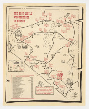
The Best Little Whore Houses in Nevada
1989
This map of the state of Nevada’s “prime virgin territory”, illustrates the locations of 36 brothels around the state, following the highways from Las Vegas in the south up to Carson City and Reno, and east to Wells and Ely; an inset pr...

The United States as seen by Californians
1947
Adapted from Arnold’s book ‘California Brags’, illustrated by Charlene Bisch, and published simultaneously.The map depicts the continental United States from a Californian’s perspective. AsDavid Rumsey reports: “A humorous pictoria...

A More or Less Inaccurate Map of Taos, New Mexico
c1940
A humorous map of the Taos region by a well-known artist of the Taos School, Ward Lockwood. Included is the area from Rancho de Taos to the Taos Pueblo. The title notes that the map is the “Guide to the Land of Manana in a State of Peace&rd...
