Featured Maps
South Africa
1958
A dramatic map of South Africa at a time when it was “The Union of South Africa" and included the former German colony of Southwest Africa. Also published in the same year in a smaller version, this example was printed in The Netherlan...
Geschichte des Kakos
1955
“Once upon a time, in the Caribbean, you could buy a beautiful woman for 100 cocoa beans” (1920s advertising slogan).A comprehensive pictorial history of the origins and production of chocolate, presumably commissioned for, but apparently...
Where We Grow Our Trees
1948
First published in 1943, the map illustrates the different forest regions of the US, and includes vignettes of the trees that are typical of each.“With the aid of research laboratories and American genius for invention, more and more industries are u...
Holland West-Afrika Lijn
1949
An important post-WWII map showing West Africa carved up by Colonial powers: Britain, France, Spain, Portugal and Belgium. Vignettes throughout the map highlight the rich natural resources of the territories, and how they may be accessed by the flight ro...
Plan de la Baie de Monterey
1797
First edition, derived entirely from original sources and the earliest obtainable map of the region. Showing the Presidio and the Mission of St. Charles, anchorages, rocky outcrops. La Perouse landed at Monterey in September of 1786, and remained there ...
A More or Less Inaccurate Map of Taos, New Mexico
c1940
A humorous map of the Taos region by a well-known artist of the Taos School, Ward Lockwood. Included is the area from Rancho de Taos to the Taos Pueblo. The title notes that the map is the “Guide to the Land of Manana in a State of Peace&rdq...
The United States as seen by Californians
1947
Adapted from Arnold’s book ‘California Brags’, illustrated by Charlene Bisch, and published simultaneously.The map depicts the continental United States from a Californian’s perspective. AsDavid Rumsey reports: “A humorous pictori...
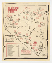
The Best Little Whore Houses in Nevada
1989
This map of the state of Nevada’s “prime virgin territory”, illustrates the locations of 36 brothels around the state, following the highways from Las Vegas in the south up to Carson City and Reno, and east to Wells and Ely; an inset pr...
BART Opens Embarcadero. First Port o'call in San Francisco.
1976
This charming bird’s-eye-view of downtown San Francisco looks north from above Market St. towards North Beach and Telegraph Hill. It announces and celebrates the opening of the Embarcadero Bart station, which took place on May 27th, 1976. This op...
Ollie Hammond's Steak Houses: Dinner Menu
1948
“Tonight’s special THE VERY FINEST FILET MIGNON STEAK hashed browned or shoestring potatoes toasted sesame seed roll and coffee $2.25”Tourist map of Los Angeles and environs featuring the three Ollie Hammond’s Steakhouses at Beverly ...


